

[ad_1]
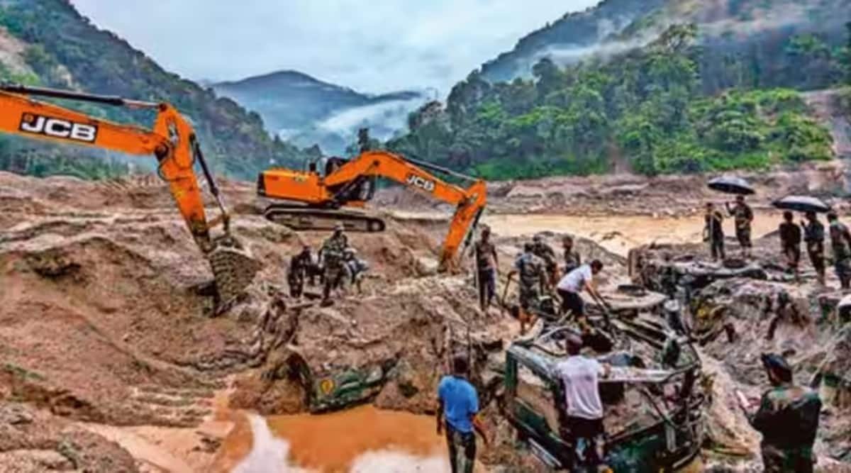
In the early hours of October 4, the southern bank of the South Lhonak Lake in Sikkim burst open, leading to an outflow of huge amounts of water. Flowing over the steep mountain slopes in the Teesta basin, a lethal mix of icy water and debris washed away whatever came in its way. The floods caused heavy damage to the Chungthang Dam and hydropower projects of NHPC. More than 35 people were killed, 14 bridges were washed away or submerged, 1,320 houses were severely damaged, drinking water supply lines and sewage networks were damaged and widespread damage to highways was reported in North Sikkim, Gangtok, Pakyong, and Namchi districts. The floods damaged sections of National Highway 10, connecting Sikkim with the rest of India.
2There are several hypotheses — one or more spells of intense rainfall in the lake area, a landslide or avalanche or an earthquake. In 2021, a collaborative study by researchers from IIT, Roorkee, Indian Institute of Science, Bangalore, University of Dayton, USA, University of Graz, Austria, and the Universities of Zurich and Geneva in Switzerland highlighted that the South Lhonak Lake had grown significantly in recent times and was susceptible to a GLOF.
Glacial lakes are formed near the snout of glaciers when meltwater accumulates. In recent times, such lakes have been forming with increased frequency because the increased warming of the troposphere has glacier melting. The embankments of these lakes consist of loose deposits of glacier moraine, rocks, boulders, soil and ice. Since these embankments are not properly compacted, they have a high vulnerability quotient. They can fail if the lake water level rises rapidly due to intense rainfall or if a portion of the glacier is detached from the main body and plunges into the lake, generating high waves. These waves could hit the embankment forcefully. Earthquakes could also destabilise the embankment and water seeping in through the embankment could cause erosion.
Catchments of the three river basins in north and northeast India have a large number of glacial lakes. In March, the ISRO’s National Remote Sensing Centre (NSCRC) released a glacial lake atlas of the Himalayan River Basins. NRSC used images acquired by RESOURCESAT-2 satellite during 2016-17 to prepare this atlas, which has identified more than 28,000 glacial lakes of more than 0.25 ha.
In a widely quoted scientific paper in Nature Communications this year, geologist Caroline Taylor and her colleagues noted that GLOFs can arrive with little prior warning. The authors concluded that more than nine million people in High Mountain Asia (HMA) — its surrounded by the mountain ranges of Tien Shan, Pamir, Hindu Kush, and the Karakoram in the west, the Himalaya in the south and southeast, and Qilian Shan in the east — are vulnerable to glacial lake outbursts. This is a cause for concern.

The Sikkim State Disaster Management Authority has identified more than 300 glacial lakes in the state. Of these, 10 have been identified as vulnerable to outburst floods. NRSC has identified 733 glacial lakes in Sikkim. The Geological Survey of India has found that 13 of the 486 glacial lakes in Uttarakhand are vulnerable to GLOFs. A 2021 study led by Delhi University scientist Suraj Mal reported that Jammu and Kashmir has the highest number of vulnerable glacial lakes followed by Arunachal Pradesh and Sikkim. Different studies use different data and methodologies. Hence, their outcomes are not always comparable. But one thing is certain: GLOF threat is rising with time. India has witnessed at least three highly devastating GLOF events in the Ganga and Brahmaputra basins over the last decade — at Kedarnath in 2013, Chamoli in 2021 and Sikkim in 2023.
Threats from GLOFs are likely to increase with time due to global warming. Multi-pronged action is, therefore, required to address such dangers. Intense monitoring of meteorological events near the snout of vulnerable glacier lakes is an urgent necessity. Data should be gathered at observatories and communicated to a centralised office. It should be processed in real-time to forecast the behaviour of glacial lakes and alert people. Water levels in rivers downstream of vulnerable lakes should also be monitored continuously. A nationwide programme to regularly monitor vulnerable glacier lakes by satellites and drones should be initiated. Hydrometeorological information and data gathered through monitoring should be combined to issue forecasts and warnings.
GLOF floods are different from floods caused by intense precipitation. Given increased threats due to GLOFs, standards to ensure the safety of projects in mountainous areas should be revised at the earliest.
Infrastructure projects in mountains — dams, bridges and highways — must be subjected to stringent quality control measures. GLOFs and other floods in mountainous regions have shown that buildings constructed close to rivers were the first and the worst sufferers. Construction close to rivers should, therefore, be carefully regulated.
Most Read
Scientific studies on glaciers in the country must be scaled up. Lack of funds and skilled personnel today mean that very few glaciers are monitored. Climate projections indicate that glaciers are receding in the Himalayan region. This means that new lakes are likely to form and the existing ones could expand. Glaciers are among the best indicators of climate change. It is, therefore, necessary to understand how these ice bodies respond to climate change in the different Himalayan zones — among the most data-scarce regions in the country.
The Himalayan region requires a comprehensive risk assessment that accounts for projected temperature rise, changes in precipitation patterns, and land-use/cover changes. This assessment should inform disaster risk-reduction strategies.
The writer was Director, National Institute of Hydrology and is now visiting professor IIT, Roorkee
[ad_2]
Source link